UN General Assembly Votes to Adopt New World Map Reflecting Africa's True Size

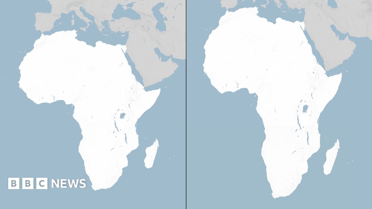
The United Nations General Assembly has voted to replace the traditional world map with a new projection that more accurately reflects the actual size of the African continent. Sponsored by Togo and backed by members of the African Union (AU), the "Correct the Map" resolution passed with the support of 164 nations, including France and the United Kingdom. The United States was the sole nation to vote against the measure, while six countries abstained.
Although the UN vote is non-binding, it is expected to prompt changes in the maps utilized by various institutions across the globe. The decision marks a significant shift away from the Mercator projection, which has been the standard for world maps since the 16th century.
The Limitations of the Mercator Projection
Designed in 1569 by Flemish cartographer Gerardus Mercator, the traditional map was originally created to assist European explorers in navigating the oceans. However, because it is mathematically impossible to represent the curved surface of a three-dimensional globe on a flat, two-dimensional chart, all map projections require compromises.
The Mercator projection accounts for the Earth's curvature by stretching areas further from the equator. Consequently, countries near the poles appear significantly larger than they are, while landmasses near the equator are minimized. For centuries, this distortion has shown Africa as roughly equivalent in size to Greenland, despite the African continent actually being 14 times larger.
Critics argue that this cartographic distortion has real-world consequences. According to campaigners, the visual shrinkage of equatorial regions has historically led to the minimization of the development needs and economic potential of countries in these areas.
The Push for the Equal Earth Projection
To address these long-standing distortions, a team of cartographers developed an equal-area map in 2018 known as the Equal Earth projection. In February, the 54 member states of the African Union formally adopted this projection, stating that it "more accurately represents the sizes of all continents, particularly Africa."
The online campaign group #CorrectTheMap highlighted the scale of the continent, noting that the landmasses of the United States, China, India, Japan, Mexico, and a large portion of Europe could all fit inside Africa with land to spare.
Speaking to the Reuters news agency ahead of the vote, Togolese Foreign Minister Robert Dussey emphasized the political weight of cartography, stating, "A fair world begins with a fair map." In an earlier UN briefing, Dussey remarked that maps are never neutral, as they shape perceptions and influence how the global standing of different peoples and continents is understood.
International Debate and Diverging Views
The resolution received strong support from France, with French Foreign Minister Jean-Noël Barrot announcing that his ministry would cease using the Mercator map. Barrot acknowledged that while changing a map does not physically alter the world, correcting a distorted representation serves as "an act of truth."
Conversely, the United States expressed strong opposition to the resolution. Yaryna Ferencevych, a US representative at the UN, argued that the debate detracted from the core mission of the General Assembly. She stated that the body was debating 16th-century map projects and their connection to reparations and "cognitive justice" instead of focusing on pressing international issues such as peace, prosperity, and diplomatic relations.
The US had previously raised objections in March when the UN General Assembly adopted a resolution declaring the transatlantic slave trade "the gravest crime against humanity."
Perception, Narrative, and Economic Impact
Supporters of the new map argue that the issue extends far beyond academic cartography. Lerato Mogoatlhe of Africa No Filter, one of the advocacy groups behind the campaign, told the BBC that the misrepresentation of Africa is a narrative issue, describing the effort to replace the Mercator map as a step toward ending "the world's longest misinformation and disinformation" about the continent.
Kenyan geographer Kioko Muendo also highlighted the economic and political implications of map distortions. Speaking to the BBC, Muendo explained that maps do more than guide travelers; they actively shape how regions are perceived in terms of investment opportunities, population, and natural resources. By visually shrinking Africa, the traditional map has implicitly downplayed the continent's true global significance.